
:quality(75)/cloudfront-us-east-1.images.arcpublishing.com/elcomercio/TMGHHISKUNBR3LPUNF6JLFKZEM.jpg)
At noon on Thursday, January 4, a earthquake It happened in Lima and Callao. Although some felt the earthquake, others did not realize it until receiving a message from Google on their cell phones.
Nowadays you can know where and when an earthquake is occurring, immediately and almost precisely. Even seconds before it occurs, some alerts can warn of the catastrophe.
READ ALSO: CES 2024 LIVE: follow the news from the first day of the technology event in Las Vegas
The first message of Google He noted that the earthquake was approximately magnitude 5. A few minutes later the Geophysical Institute of Peru (IGP) specified the measure. So, how are these earthquakes calculated? Has it changed with technology?
First you have to understand the operation of a seismograph, which is the device with which seismic movement is evaluated. This type of sensor dates back to the first decades of the last century and consisted of a pendulum and a needle.
According to Hernando Tavera, executive president of the IGP, based on this principle, the pendulum is located in a coil in such a way that, when the pendulum moves, it generates electric current, and that electric current is converted into movement. This is how you can draw the oscillation of the pendulum.
“So, these are the physical sensors of all life. Tavera indicated in communication with Trade.
Over time, we went from using a needle, ink and paper to using electric current that is converted into a computer pulse, with which the seismograph moved to the digital era with computer codes, the step to the use of algorithms that give a reading of the earthquake.
READ ALSO: Did you get an alert on your cell phone? This is how Google’s system works in the event of an earthquake
For the specialist, beyond these variations, what has changed is communication.
“Initially they were transmitted by telemetry, that is, we had poles that retransmitted the radio-type signal. After that we could send the signal via telephone line, that is, we used the telephone to call the sensor.indicated Tavera.
But if anything has accelerated analysis and communication, it is the use of algorithms. Tavera points out that they read the data automatically and give the results. Previously, the job could take up to an hour. Nowadays it takes about 3 minutes.
The earthquake in the era of the smartphone
A tool that has recently attracted attention is the one provided by Google. This is the Android earthquake alert system, or Android Earthquake Alerts System (AEAS), a free service that detects and notifies the place where an earthquake is occurring.
READ ALSO: Chile and Google will build the first submarine fiber optic cable that links South America, Oceania and Asia
As the company notes on its blog, Android’s earthquake alert system detects seismic movements around the world, and can even alert Android users before the shaking begins.
For this it has two functions. First, in the United States they work with ShakeAlert to disseminate alerts provided by a network of 1,675 seismic sensors to detect earthquake tremors and analyze that data to determine the location and magnitude of the earthquake.
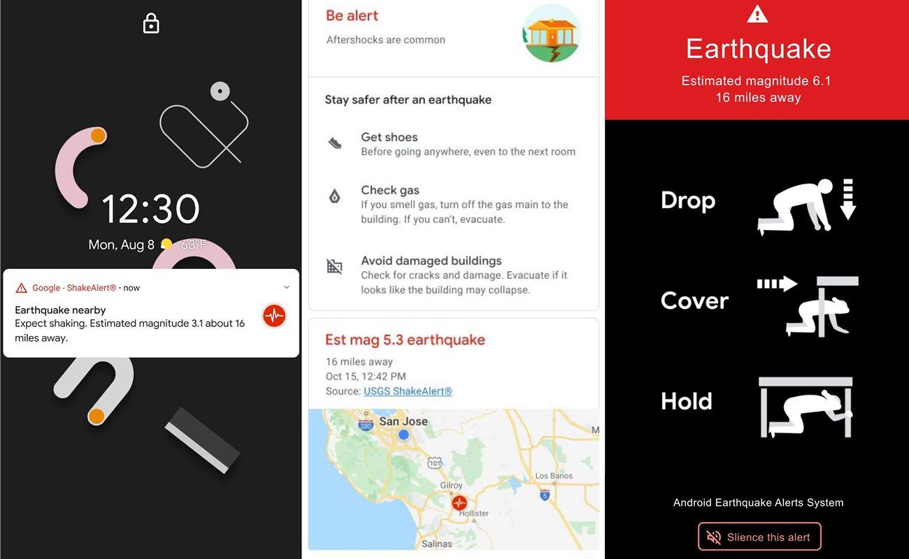
On the other hand, it also applies the crowdsourcing strategy, which is based on cell phones. “All mobile phones contain very small accelerometers that can detect vibrations and speed, signals that indicate that an earthquake could be occurring,” the page indicates.
READ ALSO: Siemens announces innovations in immersive engineering and AI for the industrial metaverse at CES 2024
That is, what is behind it is the same old system to interpret the earthquake. Tavera points out that at first the cell phones were for calling, “then they put a camera, then a radio, and they also put a motion sensor on the cell phones.” In other words, the cell phone becomes a sensor that interprets an earthquake, the information is received by the Google headquarters and it gives the message. All this work in a matter of seconds, although it can also make mistakes.
The early warning
What we are looking for today is to anticipate the seismic movement, even if it is for a few seconds. For this, around 106 stations with accelerometer sensors have been placed in Peru that can give an alert so that the population can stay safe.
“What we have been working on for two years is the earthquake early warning system, similar to the one that works in Mexico, obviously improved by all the experiences we have had”, indicated Tavera. These sensors are located along the coastal area and also on some islands.
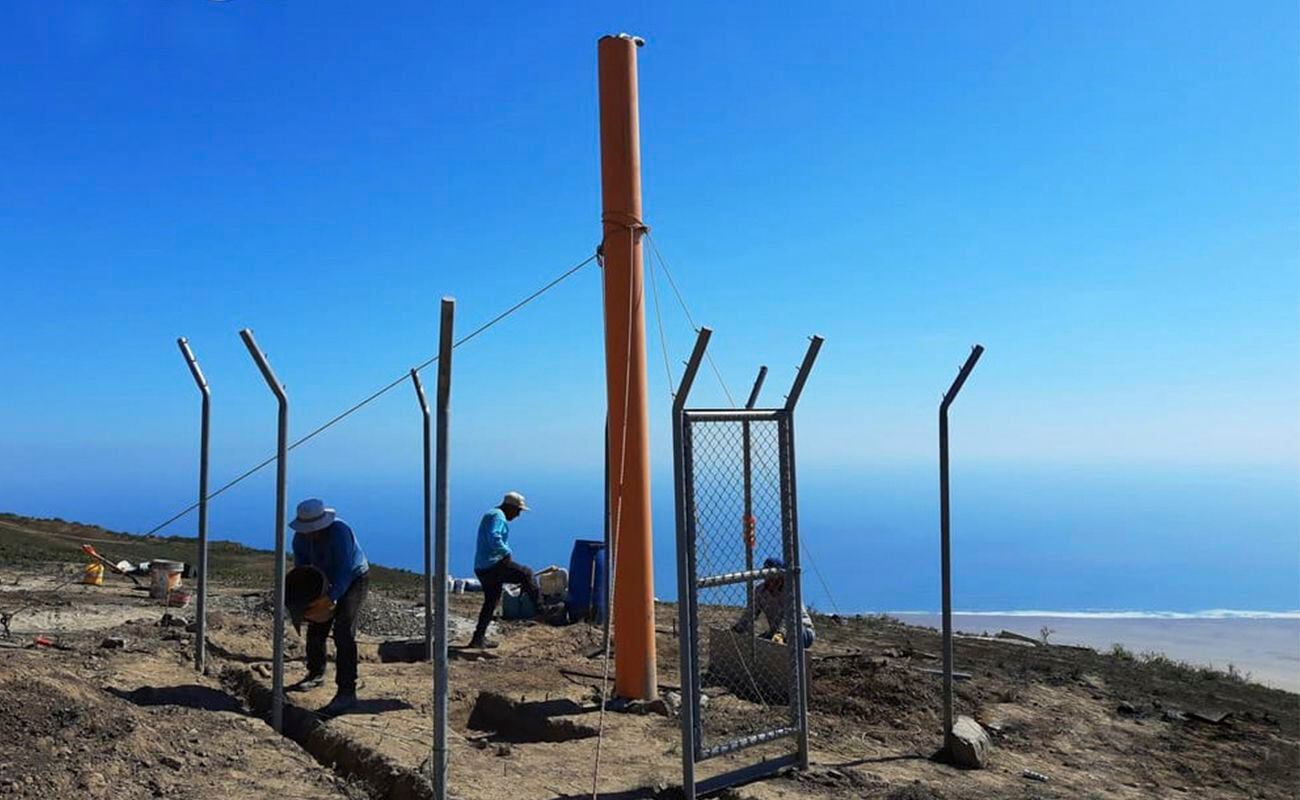
The project is called the Early Warning System of Peru (SASPe). In addition to the sensors installed on the coast, there are repeater stations and processing centers. An important detail is that alerts will be issued whenever the earthquake is equal to or greater than magnitude six.
What is missing for it to work? Tavera points out that they are waiting for Indeci (National Institute of Civil Defense) to finish installing the warning horns. “So, the idea is that the siren sounds that will say seismic alert, seismic alert that indicates that we must leave immediately and in our case we are only going to give it to ourselves,” said the president of the IGP.

According to the institution’s website, SASPe has four missions: investigation, equipment, surveillance and monitoring of earthquake danger. To accomplish this, just over nine million soles have been invested.
Source: Elcomercio
I have worked in the news industry for over 10 years. I have a vast amount of experience in writing and reporting. I have also worked as an author for a number of years, writing about technology and other topics.
I am a highly skilled and experienced journalist, with a keen eye for detail. I am also an excellent communicator, with superb writing skills. I am passionate about technology and its impact on our world. I am also very interested in current affairs and the latest news stories.
I am a hardworking and dedicated professional, who always strives to produce the best possible work. I am also a team player, who is always willing to help out others.

:quality(75)/cloudfront-us-east-1.images.arcpublishing.com/elcomercio/BUNML4TQNVHSBOBMY5FC3QEM2M.jpg)

:quality(75)/cloudfront-us-east-1.images.arcpublishing.com/elcomercio/FGNDNEX4V5AKXF6INLTN4FLZUQ.jpg)

