
:quality(75)/cloudfront-us-east-1.images.arcpublishing.com/elcomercio/63AGKAP6B5C3RH63Z2DEDN3BBM.png)
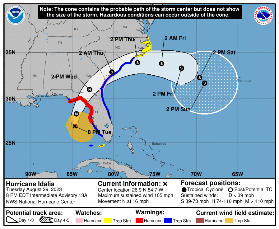
He hurricane idalia continues to strengthen as it moves over the Gulf of Mexico toward the west coast of Florida, with maximum sustained winds of 105 mph (165 km / h), and “probably become a major hurricane soon,” warned the United States National Hurricane Center (NHC, in English). In its 20:00 local time (00:GMT) bulletin, the NHC reported that Idalia will most likely become a category 3 hurricane tonight on the Saffir-Simpson intensity scale (of 5), before hitting tomorrow the western region known as Big Bend, on the north coast of Florida.
WATCH THE LIVE TRANSMISSION HERE:
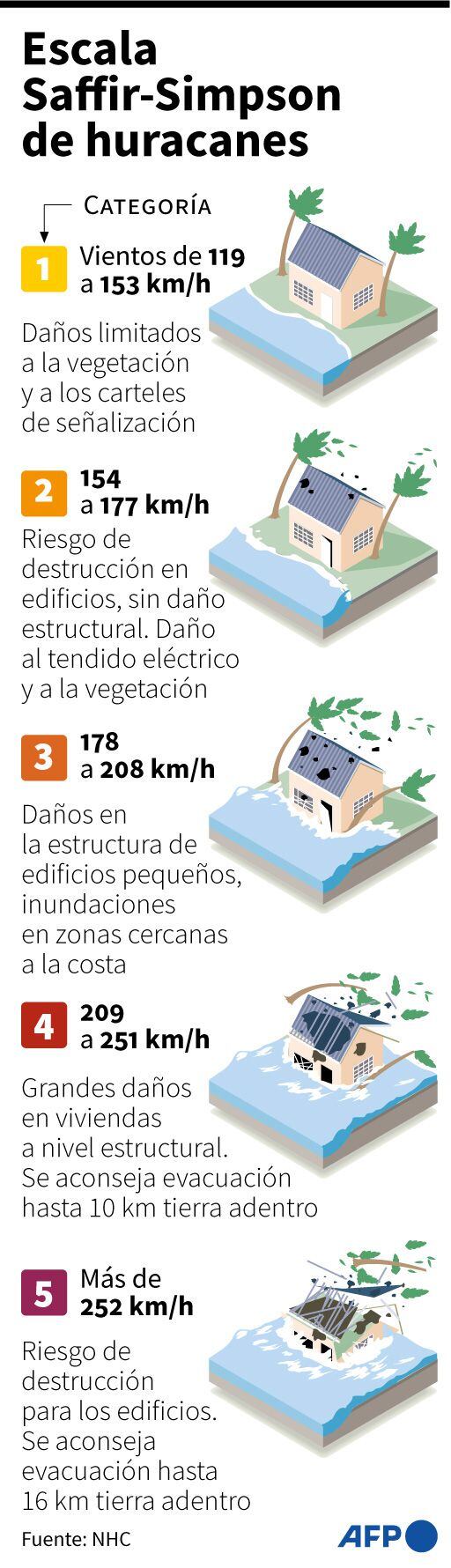
A category 2 hurricane it goes up to category 3 when its maximum sustained winds reach 111 mph (178 km/h).
LOOK: Follow LIVE the trajectory of Hurricane Idalia, which threatens Florida with powerful storm surges
After making landfall on the northern west coast of Floridait is predicted thathe center of Idalia will turn to the northeast and east-northeast, “approaching or along the coasts of Georgia, South Carolina and North Carolina Wednesday and Thursday.”
The meteorologists of the NHC indicated that possibly idalia stay as hurricane “as it moves through southern Georgia or southern South Carolina on Wednesday.”
The NHC warned that Idalia could be an “extremely dangerous” hurricane due to its storm surges, a phenomenon that the governor of Florida, Ron DeSantis, warned about this afternoon at a press conference.
“There is going to be a storm surge everywhere in the Big Bend that will have a very important and significant impact in that region.whether the walls of the hurricane hit it or not,” he alerted the population this afternoon DeSantis from tallahasseeThe state capital.
He republican governor urged residents in evacuation zones, especially if they are in low-lying or coastal areas, to seek shelter in shelters (up to 50 have been enabled), hotels or friends’ homes located in higher and safer places.
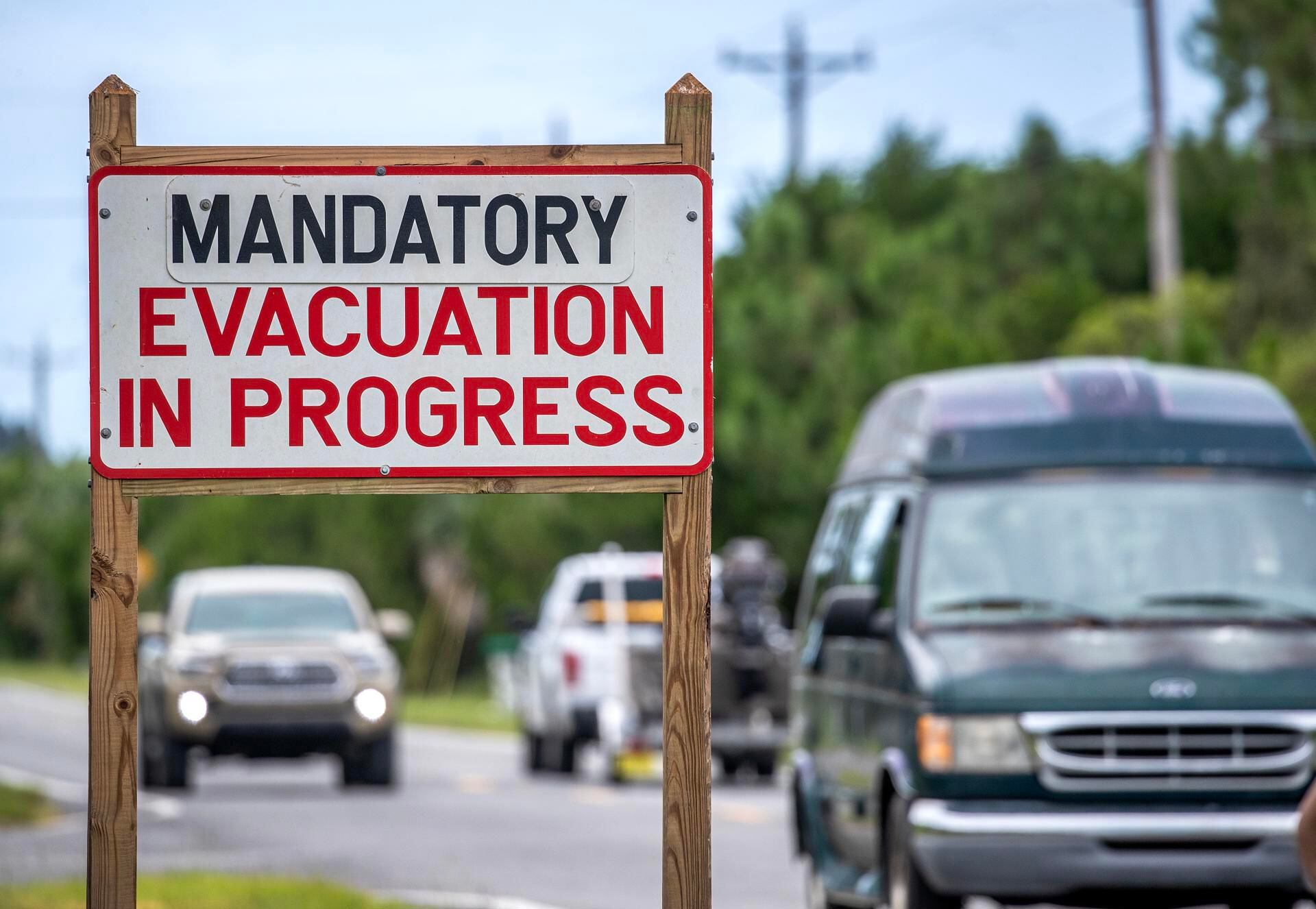
“You have to go now. If she doesn’t, tomorrow morning will be too unpleasant, and, if you decide to stay, the lifeguards will not be able to locate you until after the hurricane”, he insisted.
More than 1.6 million people have orders to evacuate their residences in Florida before the proximity of hurricane category 2 idalia which, according to forecasters, will make landfall in the northwest of the state with category 3 winds (starting at 111 miles per hour or 178 kilometers per hour) this Wednesday.
Idalia, the third hurricane of this hurricane season in the Atlantic, now has maximum sustained winds of 165 km/h and is located 155 miles (250 km) west-southwest of the city of Tampa (west shores of Florida) and 245 miles (390 km) south of tallahasseethe capital, in the center of the state.
It is moving north with a forward speed of 16 mph (26 km/h).
He governor pointed out that the impact of the vortex walls of idalia it will happen tomorrow morning and that storm surge could reach 10 to 15 feet (3-4.50 meters) in some of the affected areas.
The experts of NHC indicated that parts of the west coast of Floridathe Florida Panhandle, southeastern Georgia, and the eastern Carolinas could record 4 to 8 inches Tuesday through Thursday, with isolated higher totals of up to 12 inches.
Source: Elcomercio
I am Jack Morton and I work in 24 News Recorder. I mostly cover world news and I have also authored 24 news recorder. I find this work highly interesting and it allows me to keep up with current events happening around the world.


:quality(75)/cloudfront-us-east-1.images.arcpublishing.com/elcomercio/Y3FX5C6MRRGF5M3BHTPWKJBLAU.jpg)
:quality(75)/cloudfront-us-east-1.images.arcpublishing.com/elcomercio/2YOZEGVYDRB7ZCJRH7QNZ37PMA.jpg)
:quality(75)/cloudfront-us-east-1.images.arcpublishing.com/elcomercio/2J6GA6I625E6LHBFNAYMAZUJJI.jpg)
